
Friday, 3rd August.
I decided to eat at the Royal Hotel last night despite there being plenty of other options. I simply couldn’t be bothered moving once I’d sat down. A pint and a pizza later I was beginning to feel seasick. I’d chosen a table standing on the springiest floorboards in Kirkby Lonsdale, positioned on a busy thoroughfare. Every time somebody walked past there were ripples on my pint and the world would appear slightly blurry before settling down again. This happened at least twice a minute.
Once fed I opted to venture to the nearest pub I could find with a solid floor, which turned out to be next door. And what a find! The Barn is run by my (!) hotel but is much more down to earth, not only featuring a brewery in the corner, but also several industrial coffee grinders. Heaven! With a stone floor to boot! Once I was the only person remaining I headed back next door and was the only person remaining there as well, so I had a final pint while the staff cleared up around me.

Two photo options, The Barn bar or The Barn urinals. No contest!
After a night of not being folded in half (but being too hot because the windows wouldn’t open) I prepared myself for a wet day. I had planned to start early so I could get down from the higher ground before the heavy rain arrived, so was in for breakfast by 7:30, a good 75 minutes before anyone else turned up. I know this because I was still sitting there drinking very good coffee and pondering a changed forecast, now featuring all day drizzle which wouldn’t give me any views but was not worth avoiding. Unlike yesterday nothing exciting happened at all during those 75 minutes.
It was one of ‘those’ days, to be honest, though the middle section was great. If I’d been sitting at home I wouldn’t have dreamt of going walking, but of course I have no option on these jaunts, so off I went. The first 2 miles were pleasant, through fields and along tracks. The next 2 weren’t, as the humidity increased and the flies appeared. The next 2 were better, climbing gradually along a valley. 6 miles down, 10 to go, and at this point I had to leave the valley I was in, cross Gragareth (a 627 metre lump) and descend via another valley to Ingleton.
The path was clear to start with and gradually gained height. The cloud base was at 250 metres so at this point everything disappeared into a grey murk. I descended slightly to a dried up gorge, where the ex-stream had left a bowl of smoothed rocks. From here I needed to climb alongside a wall to a junction with another wall about half a mile up the hillside. My problem was no path any more and bracken, which was well above my height so I had no idea where I was. I spent 20 minutes fighting my way through, all the time looking down in case there were potholes (they’re everywhere round here), before the bracken gave way to heather and I found the first wall, then the junction.

Visibility at 300m altitude.

Dry stream bed.
As visibility was now down to about 20 metres I studied the map and decided a bearing of 80 degrees would get me to the summit trig point in about half an hour. I have to say I felt rather pleased with myself when that’s exactly what happened. From here there was a ridge track, then a descent (no path again) into a very drab valley, though at least I’d dropped out of the cloud. After such an exciting stretch the next 3 miles were unbelievably boring...

Visibility at 600m, the Trig Point!

Moody cows.
...and then I saw an ice cream van. I’ve no idea why I didn’t take a photo, but it was quite surreal. I’d arrived at the top of the Ingleton Waterfall Trail, £6 per adult, family discount £15, but the top is in the middle of nowhere. This, as it turned out, was to be my final 2 mile descent to Ingleton. Now I’ve got several pet hates, but I save a special place in my personal loathing for having to pay to see a bloody waterfall. It’s OBSCENE!!! What would my £6 be spent on? I could see nothing that required financing, though judging from the amount of water in the falls compared to everywhere else I presumed it would contribute towards diverting all of the water in Yorkshire to here. It had only been drizzling but the water fell in torrents!
Refusing on principle to enjoy the trail (though I did take obligatory photos of the two main falls) I descended grumpily, and to make matters worse I was no longer alone. The weather had improved (sort of) and brought people out in their, er, dozens. As I approached the entrance / exit I had decided to ask the toll booth person how my contribution would be spent, but at the last minute changed my mind. I walked purposefully towards the booth, barked “Good afternoon” at the gentleman standing there and continued without a pause.
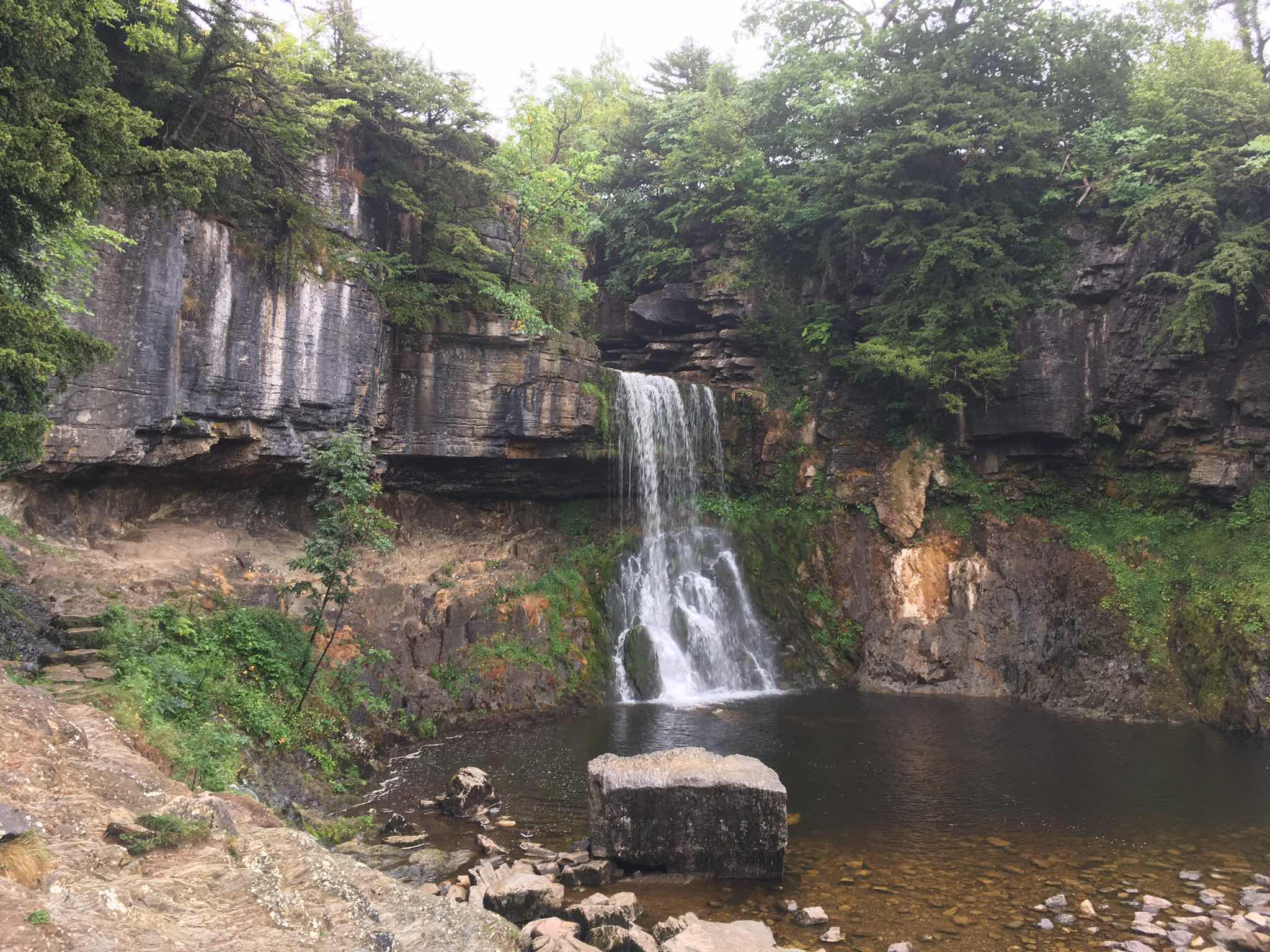
That’ll be £3 please...

...oh and another £3. Kerching!!!
I’m staying in the ‘pleasant but not brilliant for the price’ Seed Hill Guest House in the centre of Ingleton, and drinking / dining in the very average Wheatsheaf Inn. Ingleton itself, however, is one of the ‘very important places in my life’. I was a latecomer to “big walks”, and it was here that I stayed (in the caravan site no less!) before my very first “big walk”, the Three Peaks. I did that walk with two friends, Tony and Mike (aka. Fatman), and Mike is arriving tomorrow morning to do the next couple of days with me. It’s sure to come up in conversation.
To say I was under-prepared for that first “big walk” on March 26th, 1983 would be a gross understatement. I know it was March 26th, 1983 because United lost to Liverpool in the Milk Cup Final, a match I was attempting to listen to on a transistor radio whilst walking before I spilled orange squash on it and it died. How times have changed!
Stats Zone:


No comments:
Post a Comment